In late summer the slopes above Dohiaska fill with people carrying buckets. Blueberries — yafyny, in the Transcarpathian dialect — cover the ground around the lake thickly enough to justify a day's climb, and for families in Kosivska Poliana and Chorna Tysa the picking season is income rather than a pastime. Walk in with a tent in August and you are sharing the pasture with people at work.
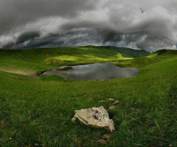
The lake below them is a broad, oddly rectangular sheet of water at 1,577 m, held in a glacial cirque under the north-eastern face of Mt Dohiaska (1,761 m). It answers to two names — Dohiaska, after the mountain, and Hereshaska, which appears in the conservation paperwork as Hereshavske. Older maps add a third, Oraty. Nobody local is troubled by the inconsistency.
Lake Dohiaska (Hereshaska) / Photo by Ihor Burbela
125 metres across and knee-deep
The measurements are the interesting part: about 125 m long by 110 m wide, a surface of 1.2 hectares — the broadest water on Svydovets — and nowhere much more than 1.2 m deep. It is a mirror rather than a body of water, which is why photographers rank it above its neighbours: at first light and again in the last hour of the day, the whole ring of Svydovets summits lands on the surface with nothing to break it.
A wide moraine ridge encircles the basin and sedge takes over along the northern shore. Snow and meltwater keep the lake topped up, and the Kosivska River starts its run from the far side. The water refuses to warm past 10–11°C even in July; algae are sparse, the only permanent residents are small crustaceans, and there is nothing to fish for.
Lake Dohiaska / Photo by Taras Tsybukh
Protected since 1984, and unguarded
Dohiaska has carried formal protection since 23 October 1984, when the Transcarpathian regional executive committee listed it as a hydrological monument of local significance — 1.35 hectares, in the care of the Kosivska Poliana village council. The designation comes with no rangers and no gate, which puts the burden on whoever turns up. Camp if you want to; there is space on the shores and this is a popular overnight stop. Leave the sedge and the shoreline as you found them.
Local belief credits the water with restorative powers rather than a tragic love story, which is unusual here — most Svydovets lakes come with drowned lovers attached. Take that as you like; after nine kilometres of ridge walking, cold mountain water is bracing without help from folklore. Boil it before you drink or cook with it.
Lake Dohiaska (Hereshaska) / Photo by Ярослав Тюрменко
Nine and a half kilometres from Drahobrat
Nothing here is a short walk, which is the practical difference between Dohiaska and Ivor, its small neighbour three kilometres from the ski lifts. The standard approach starts at Drahobrat, climbs Mt Stih and passes Lake Vorozheska, and the first sight of Dohiaska opens from the Apshynets ridge. Follow the blazes — two white bars with a yellow one between them. It is about 9.5 km one way over open ground with real ascent in it, so budget the whole day and carry your own water.
The alternative is a full day out of Yasinia: down to Chorna Tysa, then over Tatulskyi Menchul and Velykyi Kotel and straight in to the lake — around 20 km, manageable between dawn and dusk by anyone reasonably fit. Before you leave Yasinia, the local museum and the 19th-century wooden Church of the Ascension are minutes off the route. Multi-day traverses out of Kvasy string Dohiaska together with Vorozheska, Apshynets and Ivor over 36–52 km and three days or more.
Lake Dohiaska (Hereshaska) / Photo by Алексей Медведев
Reaching the trailhead
Trains reach Yasinia station, five to six hours out of Lviv, and Kvasy, both on the Rakhiv line; from either you walk. Driving, head for Ivano-Frankivsk, the H-09, then the Drahobrat turn beyond Yasinia. The last section up to the resort is unsurfaced track needing four-wheel drive, so most people leave the car in Yasinia and take a local transfer from the guesthouse door.
On the ridge, no trees means no fire, and cutting the zherep scrub is banned, so a gas stove with spare fuel is not optional. The weather turns fast enough that a fleece and a rain shell belong in the pack in August. Tent sites are plentiful but exposed — pick one with a bank behind it. There is no cafe, no shop and no ticket office near the water.
The rest of the ridge
Drahobrat waterfall is the nearest add-on: a seven-metre cascade two and a half hours from the resort, best in the spring melt or after a downpour and thin enough to disappoint in a dry August. Lakes Vorozheska, Apshynets and Ivor lie within a day's walking, with Mt Troiaska above them at roughly 1,702 m. For a bed and a hot meal afterwards, drop back to Yasinia or Kvasy.
Люди! Не будьте тупі! В високогірних озерах заборонено купатися! Місце гарне, але забагато туристів, які приїжджають на газонах, буханках, різноманітних позашляховиках, квадроциклах та вонючих ендуро байках, які чутно за кілометри 😞
Олена Собко (SOlena)
5/5
З інтернету:
Знаходиться озеро Герешаска на висоті 1577 метрів над рівнем моря. Довжина його – 125 м, ширина – 110 м, загальна площа складає 1,2 га, а глибина – до 1,2 м.
По факту:
Облаштована пікнікова зона.
Можна поплавати.
Вода бодрить) холодна
Ірина Бєлова
5/5
Місце справді гарне, але туристів тут занадто багато. Особливо дратує, що деякі приїжджають просто на газони, буханках, позашляховиках, квадроциклах та гучних ендуро байках, які чути здалеку. І ще варто пам’ятати, що у високогірних озерах купатися заборонено.