On 13 June 2025 an excavator was working at almost 1,700 m on the slopes of Troiaska, mixing concrete for the footings of a mast to measure wind speed. The men on site said the permits were in order and referred questions to the Ust-Chorna village council, which had posted notice of a strategic environmental assessment the day before. For a summit whose entire appeal is that hardly anyone comes here, it was a strange thing to walk into.
Troiaska is 1,702 m and sits in the middle of Svydovets, well away from the Drahobrat end. It has no edelweiss cliffs like Blyznytsia and no chairlift like Stih. What it has is position: you cannot reach it without committing to a long day on the ridge, and that filters out almost everyone.
Mt Troiaska / Photo by Piotrgrzys
A summit you cross rather than climb
Forest and dense krummholz cover the mountain to somewhere around 1,300–1,400 m; the dwarf pine is the slow part, and forcing a line straight through it is a beginner's mistake. Above that it opens into grass. The eastern and north-western slopes are steep, the southern side is gentle, and that is where the path goes.
Nothing about the top is technical. The difficulty is the distance to it and the height gained on the way, which is why Troiaska is nearly always one bead on a multi-day string rather than a day's objective. The reward is a kind of quiet that Blyznytsia and Stih lost years ago.
Photo by Patrol Offroad
Its neighbours on the map
The summit stands at roughly 48.2837 N, 24.1461 E on the main crest of Svydovets in Zakarpattia; Chorna Tysa is the nearest village worth starting from. Unhariaska rises to the west at almost the same height, a saddle runs north to Tataruka at around 1,707–1,711 m, and Dohiaska, about 1,761 m, closes the view to the south-east.
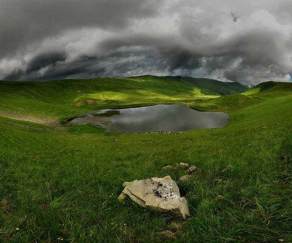
Drop east off the top and you come to Lake Apshynets at 1,487 m — close enough that Troiaska is sometimes given a lake name of its own. The Apshynets valley below is a hydrological reserve of national importance, with a management regulation approved in 2012.
Polonyna near Troiaska / Photo by Богдан Сливка
Four lakes within a day of the summit
Apshynets is small: about 1.2 hectares, roughly 124 by 100 m, and nowhere deeper than 3.3 m, with sedge and sphagnum along the edges and newts in the shallows. Dohiaska, also called Hereshaska, sits south-east at around 1,577 m and is the largest sheet of water in the massif; it rarely warms past ten degrees, and the slopes above it turn blue with blueberries in August.
Vorozheska, at around 1,460 m, is two basins rather than one, fed by the meltwater of an old snow patch and shrinking as the snow patch does. Ivor, near Drahobrat at around 1,600 m, is the clearest of them. All four sit on the same web of paths as Troiaska, and each has its own entry here.
Lake Ivor
Routes over the top
The classic Svydovets line, Vershynamy Svydovtsia — Along the Peaks of Svydovets — passes the southern foot of Troiaska, linking Yasinia with Ust-Chorna in either direction and stringing together most of the summits and lakes on the way. A branch turns north off it and drops over Tataruka to the Okole pass at about 1,193 m; the shortest sensible outing on Troiaska is that stretch in reverse, roughly 7 km from the pass.
Two days will take you from Berliaska over Unhariaska and Troiaska down to Lake Dohiaska. Full traverses of 50 km and more take in Blyznytsia and Velykyi Kotel on the way out to Kvasy or Chorna Tysa. Whichever you choose, it is ridge walking with real ascent, not a stroll between viewpoints.
Getting there, and what to carry
Chorna Tysa and neighbouring Yasinia are the practical start. Trains run to Rakhiv and Yasinia from Lviv, Kyiv and elsewhere; buses come from Ivano-Frankivsk, Yaremche and Uzhhorod. Driving, aim for Ivano-Frankivsk and then Nadvirna, Yaremche and Yasinia. From the village everything else is on foot, so budget a full day at the least and plan on sleeping out.
Carry the full kit: tent, bag, boots you have already walked in, food and cookware. There is no firewood on the open tops and damaging the dwarf pine is prohibited, so you need a gas stove and enough gas to see the trip out. Fill up at springs and boil what you take. Weather on the crest turns fast even in July — waterproofs and a warm layer, every time.
Хотілося, щоб збирачі ягід, пильнували своїх псів, бо таких велетнів мають і зовсім за ними не дивляться. До того ж, коли бачать, що ті (а їх декілька) біжать на людей, які проходять, то навіть не намагаються їх зупинити. Страшно, коли на тебе біжать собаки. Ніколи не знаєш, що в їх головах. Ще й ричать так, що серце в п'ятки ховається.
Igor Golysh
5/5
Трояска, як своєрідний "роздоріжний" камінь на Свидовці. "Червоний" маршрут прямує на г.Унгаряску, г.Велику та Малу Куртяску і далі - в долину р.Тересва. "Синій" маршрут іде на г.Татаруку, до витоків Чорної Тиси та через перевал Околе до основних хребтів Центральних Горган. Зліва від хребта - мальовниче озеро Догяська, а правіше - оз.Апшинець. В тумані, які тут частенькі, можна й збитись з маршруту. Краєвиди дуже гарні!))
Андрій Довганик
5/5
Підйом із хребта на вершину дуже простий і не займає багато часу, зате звідти відкриваються справді вражаючі краєвиди. На півночі видно гору Татарука, на сході в долині - льодовикове озеро Ашинець, на південь - гору Догяска, а також на півночі - гору Унгуряска і подальший маршрут вершинами Свидовця до селища Усть-Чорна.